South Pole—Queen Maud Land Traverse III
After several weeks of preparation at Plateau Station, where the second South Pole−Queen Maud Land Traverse had ended nearly two years before, the third South Pole−Queen Maud Land Traverse got underway on December 5, 1967. Over the next eight weeks we explored 1,326 km of the Antarctic Plateau. We set up nineteen major stations for scientific measurements and collection of ice samples. The traverse ended on January 29, 1968, at geographic position 78°42.2′S, 6°52′W.
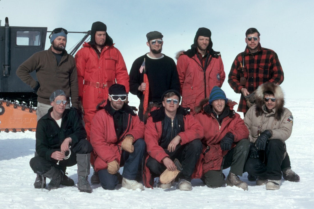
The traverse party on December 5, 1967, just before leaving Plateau Station.
The members' names, affiliations, and responsibilities follow:
Front row:
Arthur S. Rundle, Ohio State University, glaciology.
William A. De Breuck, Free University of Brussels, glaciology.
John W. Clough, University of Wisconsin, geophysics.
Phillip J. Tenney, University of Wisconsin, traverse engineer.
John Freitag, University of Wisconsin, geophysics.
Back row:
Norman W. Peddie, U.S. Coast and Geodetic Survey, geomagnetism/navigation/leader.
Michael P. Galan, University of Wisconsin, traverse engineer.
Rossman W. Smith, Ohio State University, glaciology.
Yngvar T. Gjessing, Norwegian Polar Institute, glaciology.
Carl K. Poster, University of Wisconsin, geophysics.
Unfortunately, John Freitag had to be returned to Plateau Station on December 8 because of illness.

A Night on the Antarctic Plateau, January 1968.
Winds are light and the temperature is about -30°C. The elevation is more than 3 km above sea level, and the depth of the ice is also about 3 km. Fine ice crystals in the air cause solar halos and sun dogs. Drill-Cat is in the lead, followed by Glac-Cat and Seis-Cat. The round objects behind Glac-Cat and Seis-Cat are rolling rubber tires containing diesel fuel. Behind them are sleds carrying food, tools, explosives, and science gear. The last sled carries the antenna used for sounding the ice with radio waves. The formation is unusual; normally Drill-Cat travels 8 km ahead of the other two Sno-Cats.
Winds are light and the temperature is about -30°C. The elevation is more than 3 km above sea level, and the depth of the ice is also about 3 km. Fine ice crystals in the air cause solar halos and sun dogs. Drill-Cat is in the lead, followed by Glac-Cat and Seis-Cat. The round objects behind Glac-Cat and Seis-Cat are rolling rubber tires containing diesel fuel. Behind them are sleds carrying food, tools, explosives, and science gear. The last sled carries the antenna used for sounding the ice with radio waves. The formation is unusual; normally Drill-Cat travels 8 km ahead of the other two Sno-Cats.
Plateau Station
Plateau Station, the coldest and most remote U.S. Antarctic station, was operated for only three years.
Traverse LIfe
Discovering the Russian Hut
Because we expected to see only snow and sky on this traverse, we were surprised when we saw something on the horizon on December 14.
Vehicle Work
Although vehicle breakdowns cost considerable travel time, the outstanding work of our two traverse engineers kept the loss as low as possible.
Glaciology, Topography, Geomagnetism, and Navigation
Among the scientific objectives were determining the rate of accumulation of ice (by snowfall), profiling the elevation above sea level of the surface, and measuring the geomagnetic field.
Sounding the Ice
A 40-meter hole was drilled into the ice at each of the 19 major stations. The temperature and density of the ice at various depths in the hole was measured. Then the hole was used for a seismic reflection shot to determine the depth of the ice. Special seismic refraction shots were also done to determine the velocity of waves through the ice and the rock below.
Airdrops
Fuel, supplies, and vehicle parts were delivered by airdrops from Navy LC-130 aircraft.
Pickup Flights
It is now almost the end of January, the sun is low in the sky, and the temperature is dropping rapidly. It's time to call it quits. We prepare a runway by pulling improvised drags with the Sno-Cats. On January 30 and 31 we are picked up by two flights of Navy LC-130 aircraft.
