
Welcome! I'm Norman Peddie and this is a collection of photos that I took in Antarctica in the 1960s. I hope you will find it interesting. Note that the text contains links to Wikipedia articles where you'll find additional information.
In 1963, when I was 24, the U.S. Coast and Geodetic Survey hired me to operate a geophysical observatory in Antarctica . After receiving several months' training, I traveled to Byrd Station and spent the next 12 months operating the geomagnetic and seismic observatories. Afterward I remained on The Ice to serve as geomagnetist and navigator for the first South Pole−Queen Maud Land Traverse (SPQMLT-1). In 1967 I returned to Antarctica to serve as geomagnetist, navigator, and leader of the third South Pole−Queen Maud Land Traverse (SPQMLT-3).
In 1963, when I was 24, the U.S. Coast and Geodetic Survey hired me to operate a geophysical observatory in Antarctica . After receiving several months' training, I traveled to Byrd Station and spent the next 12 months operating the geomagnetic and seismic observatories. Afterward I remained on The Ice to serve as geomagnetist and navigator for the first South Pole−Queen Maud Land Traverse (SPQMLT-1). In 1967 I returned to Antarctica to serve as geomagnetist, navigator, and leader of the third South Pole−Queen Maud Land Traverse (SPQMLT-3).
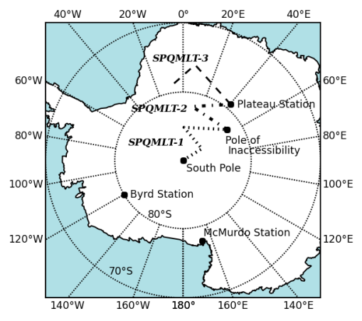
The location of Byrd Station and the routes of the traverses are shown on the map. Byrd Station is actually two stations, old and new. The old station was built during the International Geophysical Year (1957−1958). It consisted of prefabricated buildings erected on the surface, and in a few years was collapsing under the weight of snow drifts. In 1962 it was replaced by the new station, which is located six miles away and which was built within tunnels covered by metal arches. The new station was occupied continually until about 1972, after which it was used only as a summer field camp.
The three South Pole−Queen Maud Land Traverses were scientific explorations of the Antarctic Plateau undertaken in the austral summers of 1964−1965, 1965−1966, and 1967−1968. The participants included scientists from Belgium, Norway, and the United States. Our objectives were to determine the thickness of the ice sheet, the elevation and slope of its surface, the rate of accumulation, and the subglacial topography. Other objectives included profiling the density and temperature of the ice at depth, measuring gravity and geomagnetism, and obtaining ice cores and snow samples.
Revision history
2015-05-05: First publication.
2015-10-25: Text revised.
2017-02-09: Text revised.
2019-01-13: Changed name of contact form.
2015-05-05: First publication.
2015-10-25: Text revised.
2017-02-09: Text revised.
2019-01-13: Changed name of contact form.
